
The Salton Sea
The Salton Sea is a large body of salt water in southern California, USA. It lies in an area known as the Salton Trough located between the modern day Imperial Valley and Coachella Valley.
The sea was unintentionally formed more than a century ago when flood waters from the Colorado River surged through a series of irrigation canals and natural channels into the Salton Sink.
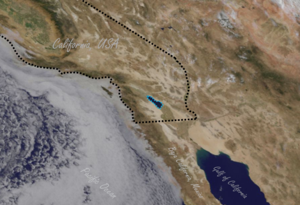
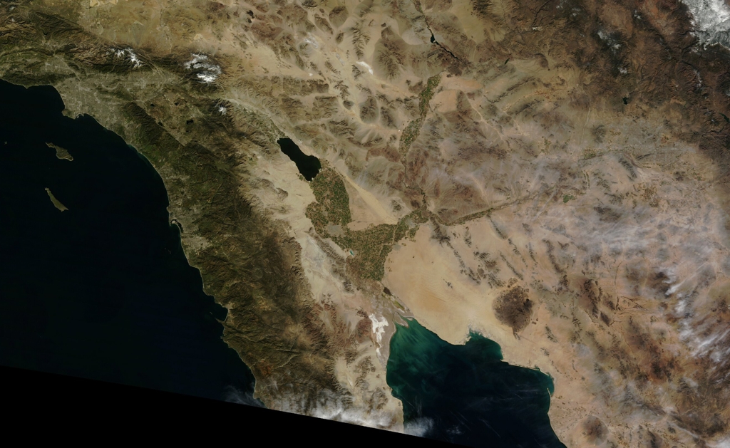
The Salton Sea (centered in image) in southern California near the west coast of the United States.
Notice that the Salton Sea is the only human made object visible from space at this distance. An outline of the state of California has been added to the image for reference.
High Resolution Image
Super High Resolution Image
Origins of the Salton Sea
The Salton Sea would not exist without the unique geology of southern California, USA and northwestern Mexico and water from the Colorado River
Over millions of years, the tectonic movement in the region, in a process called crustal spreading, caused a section of northwestern Central America, just south of the Salton Sea, to separate from the main land mass and created what is now known as the California Baja Peninsula. As the rift between the peninsula and mainland widened, the area between them subsided, filled with water from the Pacific Ocean, and formed what is now known as the Gulf of California / Sea of Cortez.
It is a commonly publicized theory that silt deposits from the Colorado River cut off the northern part of the gulf / sea from the rest of the water and created the predecessor to the Salton Sea, a much larger lake known as Lake Cahuilla. But that is not completely accurate.
Animation Depicting Creation of the Salton Sea without consideration of Tectonic Plate Movement Contribution
This animation portrays the Colorado River Delta silt deposits cutting off the northern section of the gulf / sea. It fails to demonstrate the contributions of tectonic plate movement to the creation of the sunken land that Lake Cahuilla and the Salton Sea would eventually occupy. It may lead viewers to believe lakes in this region were solely created by silt deposits, which is not correct.
Names of the Salton Sea
The land that the Salton Sea occupies and the surrounding regions have been known by many names over the years and include many modern day municipalities as well as Native American locations. Below are the names of some of the larger areas;
- Lake Cahuilla
- Cahuilla Valley
- Cahuilla Basin
- Colorado Desert
- Salton Trough
- Salton Basin
- Salton Sink
- Coachella Valley
- Imperial Valley
- La Palma de la Mano de Dios
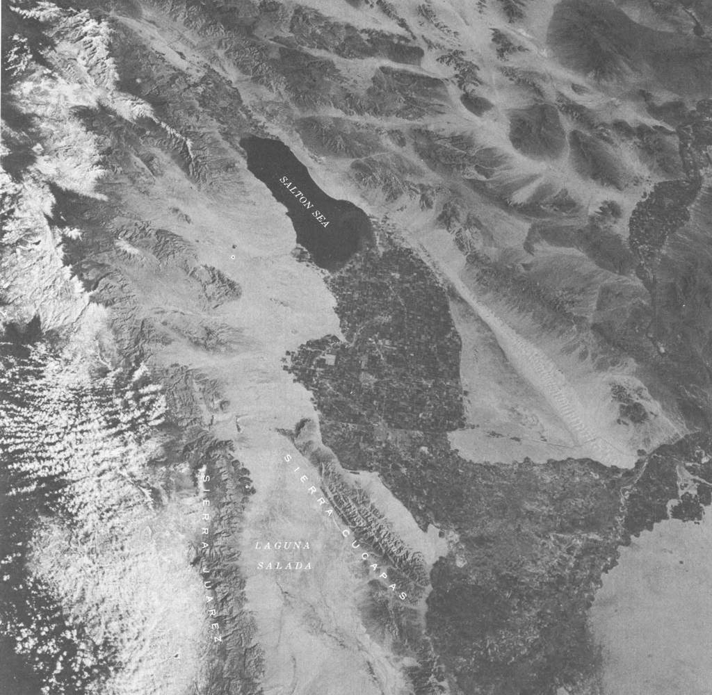
The Salton Sea as viewed from space, taken on March 11, 1969 from inside the command module of the NASA Apollo 9 spacecraft (Gumdrop)
Tectonic Plate Movement
Most geologists believe the basin where the Salton Sea is now located was never part of the Gulf of California / Sea of Cortez and was actually far above sea level in the distant past. Geological evidence strongly indicates that it was tectonic movement through the ages that caused the region to subside hundreds of feet below sea level and create the basin the Salton Sea now occupies.
Animation of Tectonic Plate Movement
This animation demonstrates the tectonic plate movement that created the California Baja Peninsula, Gulf of California / Sea of Cortez, and the region that would one day become the Salton Sea.
Silt Deposits
As tectonic movement split the California Baja Peninsula from the mainland, the area between subsided and created the Gulf of California / Sea of Cortez. Silt deposits from the Colorado River later flowed into the gulf / sea and created the Colorado River Delta.
While the bed of the gulf / sea subsided, vast amounts of silt deposited by the river caused the surface elevation westward of the mouth of the river to rise faster than it was sinking. Regions to the north of the river mouth that were above sea level subsided over time, sinking below the elevation of the rest of the delta. Eventually the delta of the river would include this unique inland delta that would one day become the Salton Sea.
Rather than sequestering the northern basin of the gulf / sea, as is commonly publicized, the silt deposits that formed the delta served as a barrier to prevent the gulf / sea from intruding into the basin.
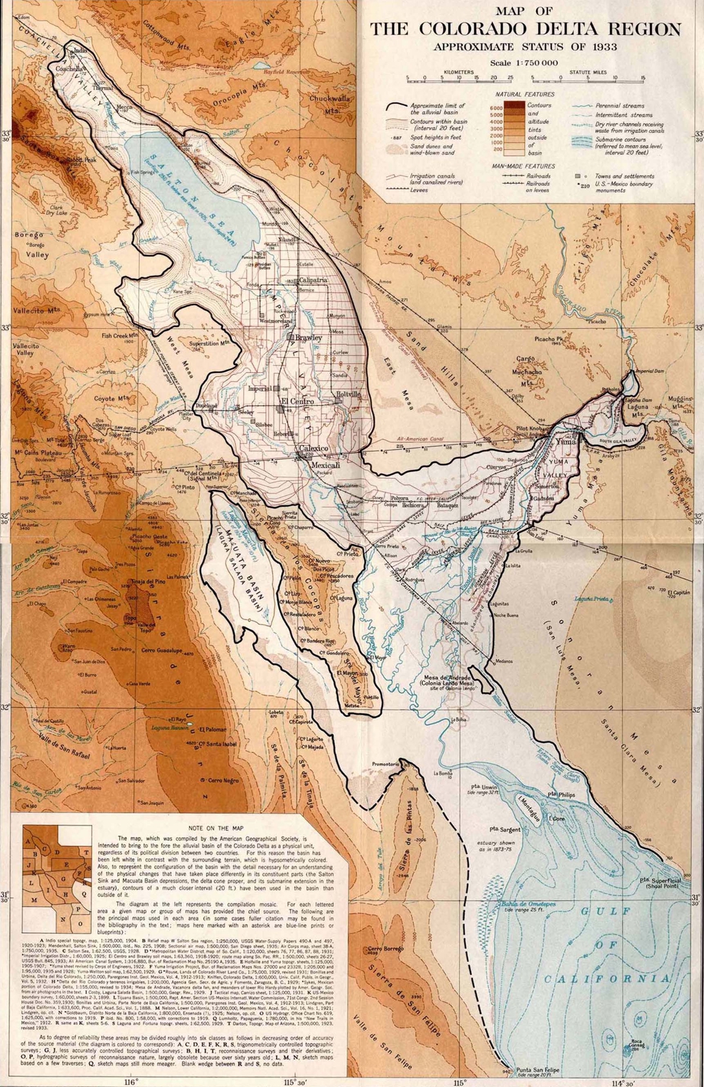
Map of the Colorado River Delta – 1933
The black outline represents the entire Colorado River Delta, including the unusual inland delta where the Salton Sea exists.
Sources & Additional InformationWater Incursions into the Valley
The region that would one day become the basin that the Salton Sea occupies subsided below sea level over many millions of years. By the time the surface was below sea level, the delta of the Colorado River had already built up to such a height that it was impossible for water from the Gulf of California / Sea of Cortez to enter the basin.
The only source of water that has ever been supplied to the Salton Basin has been in the form of rain, water from the Colorado River, and fresh water springs. Salt water from the Gulf of California / Sea of Cortez has never flowed into the region. The source of salt in the basin is from the river not from the gulf / sea.
Historically the Colorado River has flowed into the Gulf of California / Sea of Cortez, but over the millennia, it has occasionally altered its course and flowed into the Salton Basin. When the river again turned its course back to the gulf / sea, the body of water it had created was left to evaporate and disappear. Because the basin is below sea level and has no outflow, the small percentage of salt in the river water accumulated each time this cycle repeated.
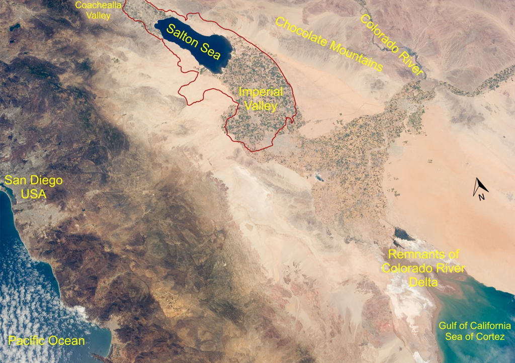
Modern Image of the Salton Sea, Colorado River Delta, and the Gulf of California / Sea of Cortez from Space
This red outline in this image approximates the shape of the inland ocean created when salt water incursions into the basin from the gulf / sea occured. Various modern locations are included as reference points.
Enhanced Image without Reference Points from Space
Notice that silt deposits from the Colorado River Delta can be seen spreading out into the Gulf of California / Sea of Cortez
Sources & Additional InformationFormation of a Lake
The path of the Colorado River has historically wound its way through Arizona, Mexico, and typically into the Gulf of California / Sea of Cortez. But over the millennia, the river’s course has naturally altered many times and flowed into the Cahuilla Basin instead of the Gulf of California / Sea of Cortez, filling the basin and creating a body of water known as Lake Cahuilla.
Although it formed in the same area as the Salton Sea, it was a much larger body of water.
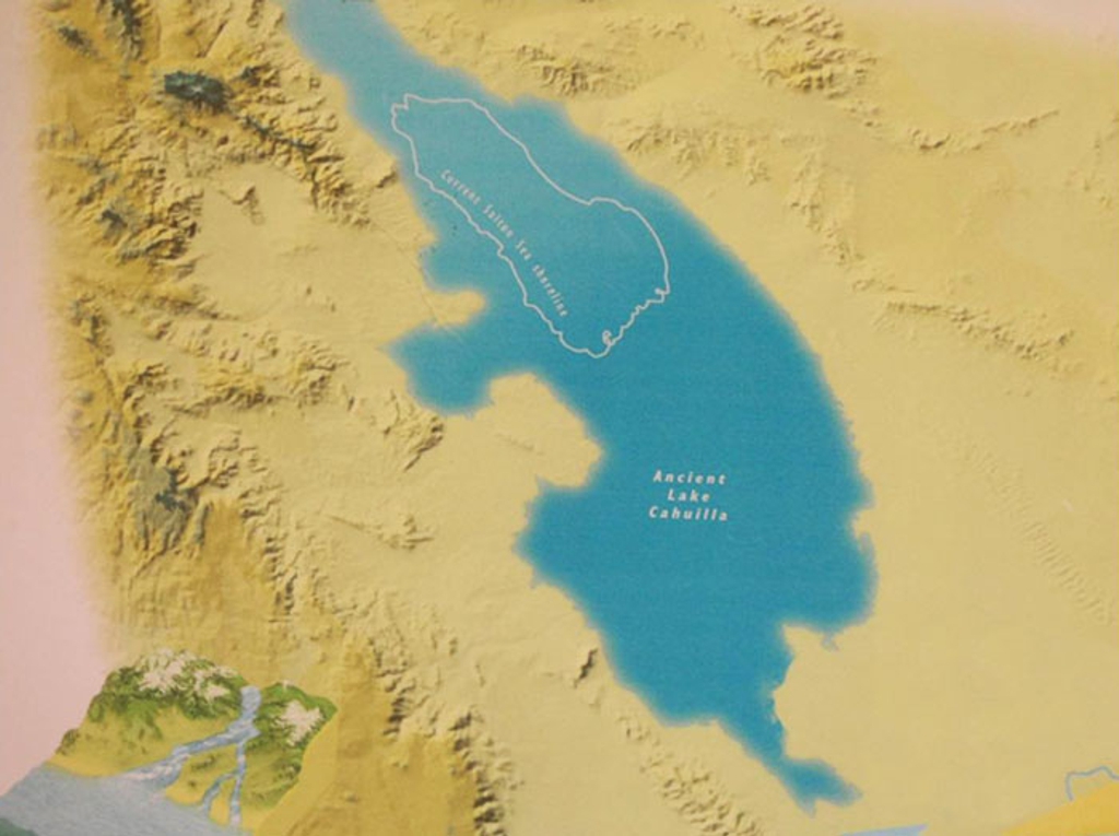
Map of Lake Cahuilla with an outline of the Salton Sea for Comparison
Sources & Additional InformationEvaporation and Rebirth of Lake Cahuilla
After Lake Cahuilla formed and the Cahuilla Basin was completely filled, the lake overflowed, cut channels through the Colorado River Delta, and allowed the excess water to drain into the Gulf of California / Sea of Cortez.
Because of flooding from the Colorado River and the easily manipulated alluvial soil of the delta, the course of the river changed many times over the years, sometimes flowing into the Cahuilla Basin and sometimes flowing directly into the gulf / sea. When the basin was deprived of its main water supply from the river, it would evaporate and disappear as the desert climate and rare rains were not enough to sustain the lake.
The cycle of filling the basin and complete evaporation of the lake would repeat itself many times over the millenia.
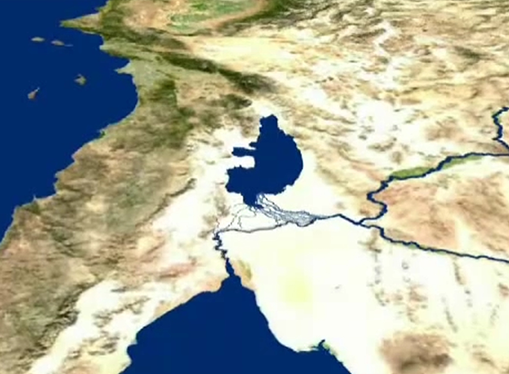
Map Showing the Flow of the Colorado River into the Cauilla Basin and then out to the Gulf of California / Sea of Cortez after the Basin Filled.
This view is looking north at southern California, USA with the Pacific Ocean to the upper left.
Next; Early History
Early History
Sources & Additional Information