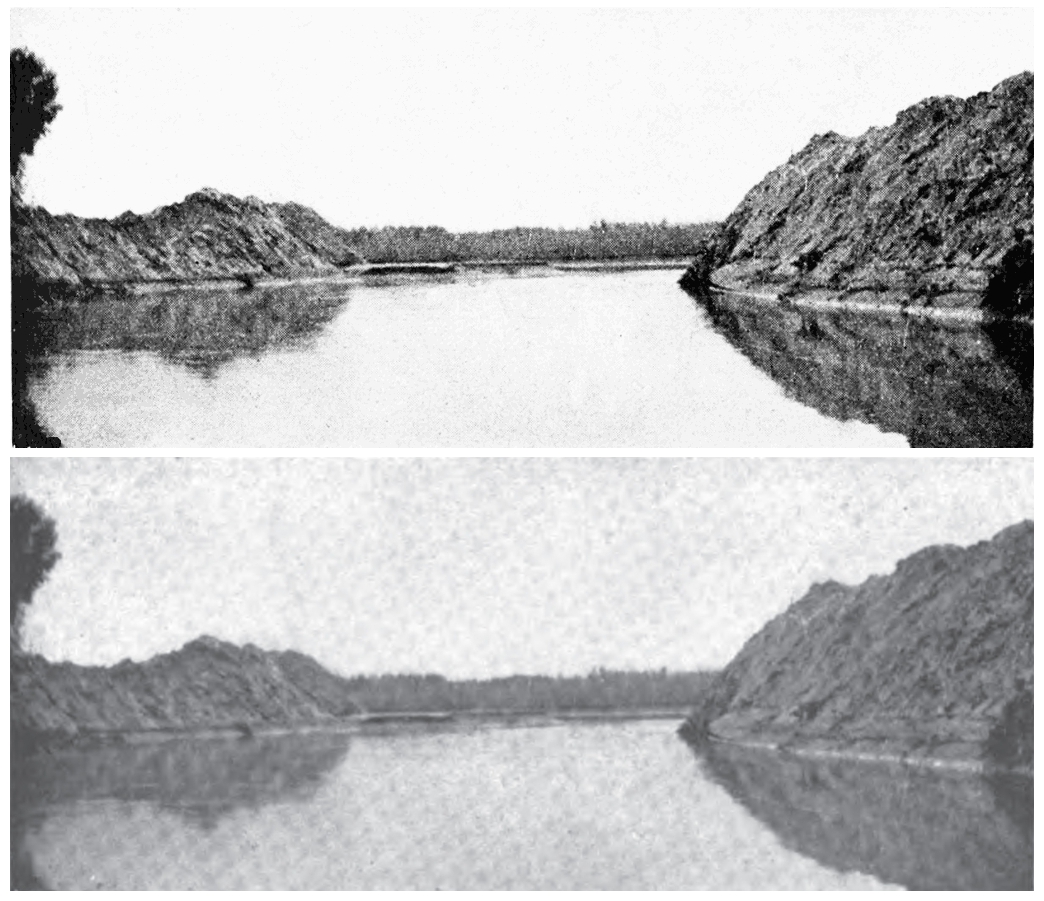
– Irony
Event Permalink: https://lifeofthesaltonsea.org/irony
Event on Timeline: https://lifeofthesaltonsea.org/irony
This content is restricted.
This website depends on JavaScript for proper functionality and display. It will not function without it.
To enable JavaScript in your browser, please follow these instructions. If you have a Plug-In such as NoScript (for FireFox or Google Chrome) enabled, please configure this website as a trusted source.
There are no plans to develop a Non-JavaScript version of this website. Thank you for your understanding.

Page (Images): A Page that contains ShortCode for a MagicZoom High Resolution or Super High Resolution or a Unite Gallery Image with High Resolution Super Zoom.
Multi Column Tag Map Book List Index
Books Available on this Website
Books Available from Other Websites
WP Custom Fields
Search & Filter
Ajax Search Pro
Ajax Search Lite
Click the drop down arrow above for additional search options ⬆
List Categories Index
Multi Column Tag Map Index
Timeline Events
Images

The definitions from our glossary are based on a range of information and sources which include Wikipedia, Merriam Webster, Dictionary.com, and Google.
Terms used on Life of the Salton Sea;
This website has been lovingly created over several years. And there are still a couple to go. Instead of waiting until everything is finished and perfect, it has been decided to make the site available to the public as of early 2020.
A thank you to the following for the support, technical expertise, and knowledge, plus other things that allows this site to exist;
Remaining items to add include most of the Recent History Timeline. The vast majority of images are available in a range of sizes, but many lack all the “behind the scenes” information such as ALT Text (Alternative Text) and other organizational tidying up.
Author: David Harriman
Editor: BJ Lindholm
Production: Meticulous Productions
Copyright 2022


People;
George Chaffey
Harry Thomas Cory
Edward Henry Harriman
A H Herber
W T Heffernan
Epes Randolph
Charles Robinson Rockwood
Joesepeh Widney
Timeline Events with People;
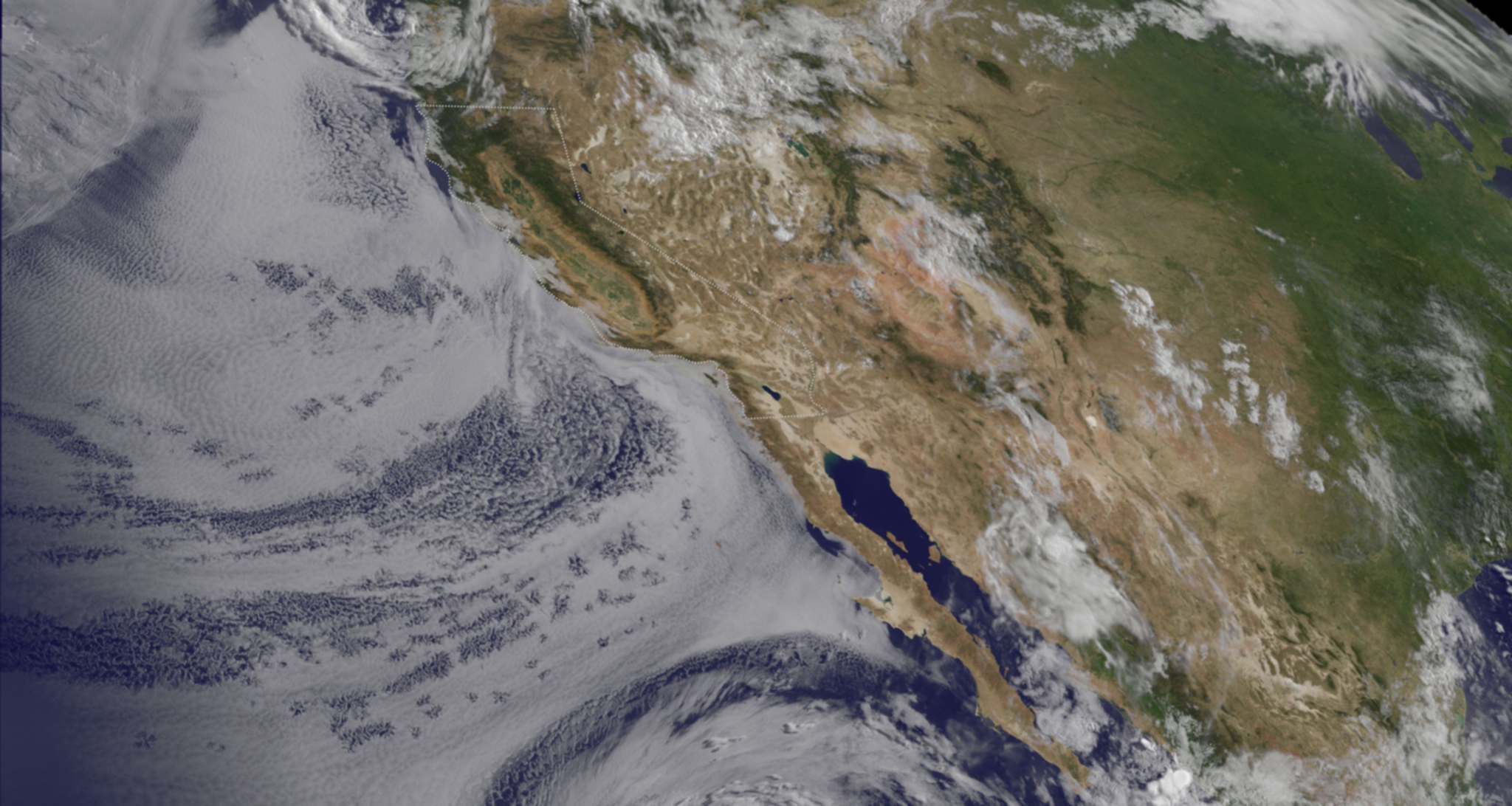
Hurricane Fabio continues to be the big tropical newsmaker in the Eastern Pacific, while the Central Pacific Hurricane Center is tracking the remnants of Hurricane Emilia. Both storms were captured on one satellite image from NOAA's GOES-15 satellite on July 16. Meanwhile, the showstopper continues to be Hurricane Fabio, although now weaker than it was over the weekend. Fabio is in the daylight and is shown in GOES-15 visible imagery. Both the infrared and visible imagery were combined by NASA's GOES Project, located at the NASA Goddard Space Flight Center in Greenbelt, Md. NOAA manages the GOES satellites, but NASA's GOES project creates images and animations. At 11 a.m. EDT on July 16, Fabio took a northwesterly turn. Fabio is now headed northwest at 8 mph (13 kmh) and is expected to turn to the north over the next couple of days, according to the National Hurricane Center. Fabio is also moving into cooler waters which is expected to weaken the tropical cyclone down to depression status. Fabio's maximum sustained winds were still near 75 mph (120 kmh) at 11 a.m. EDT. Fabio was centered near 18.9 North and 119.9 West, about 700 miles (1,130 km) west-southwest of the southern tip of Baja California. As Fabio continues to move closer to Baja California, ocean swells and rip currents are a concern along the coast there as well as in southern California.
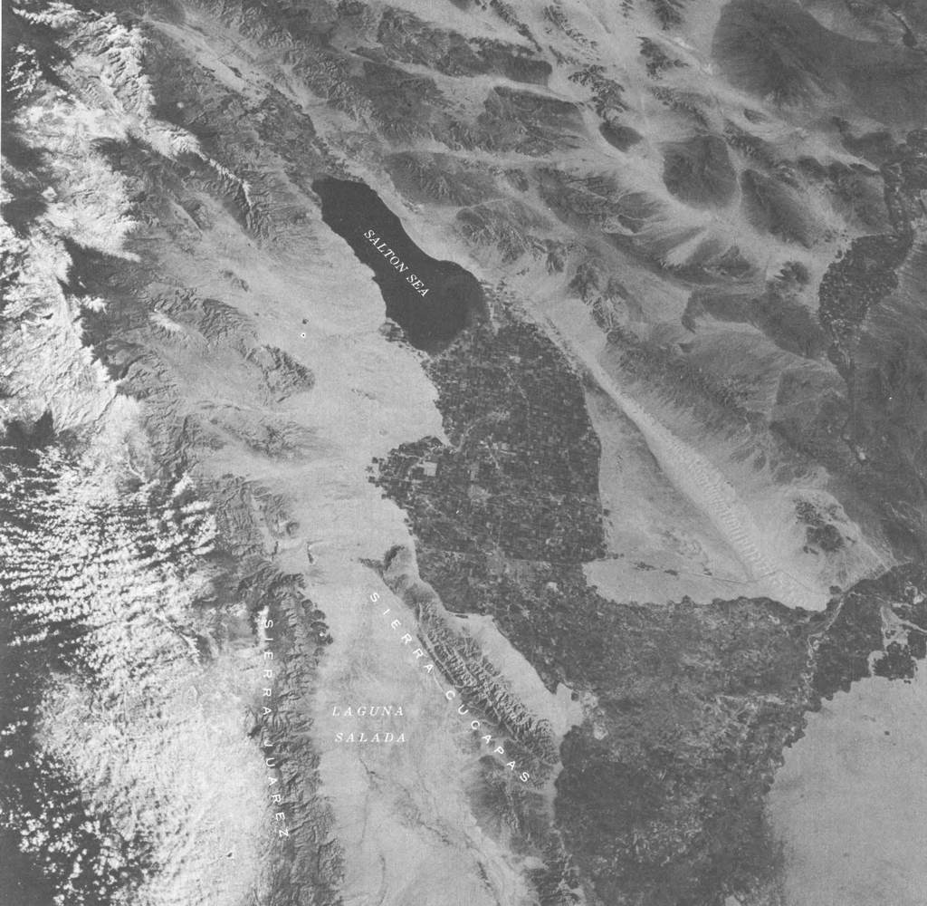
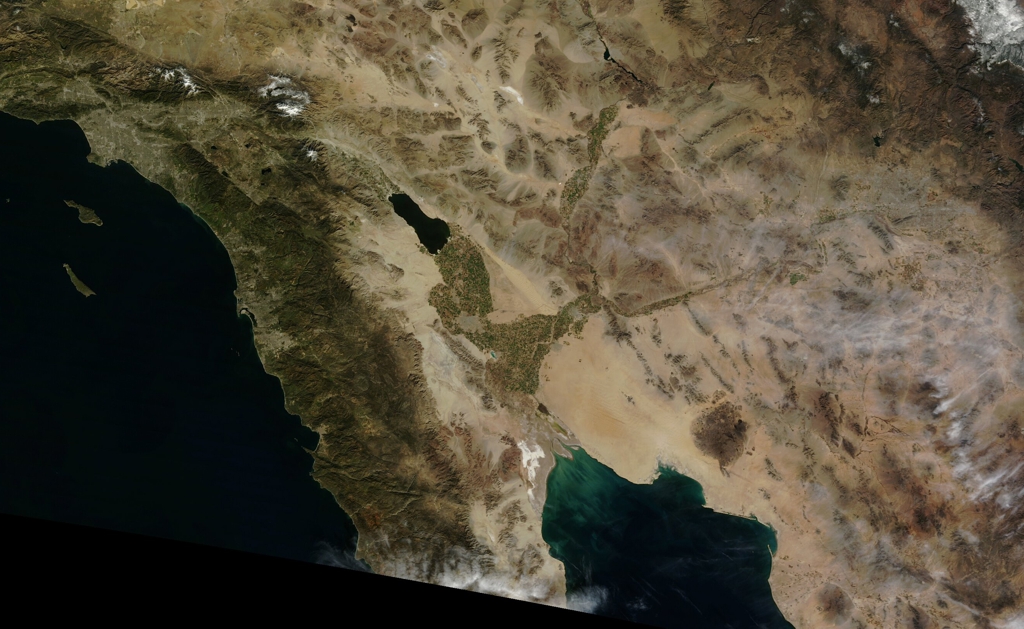
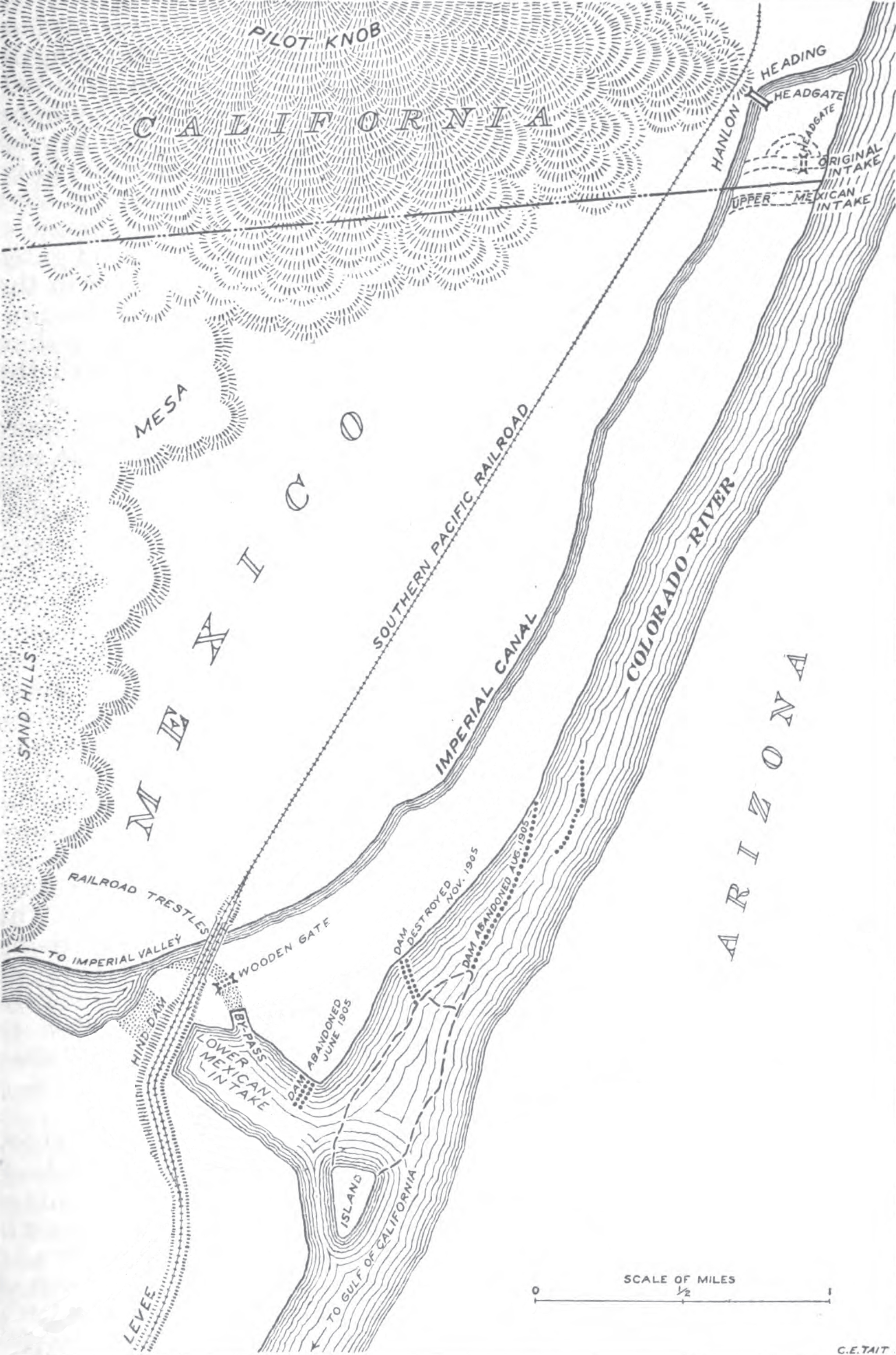
Caption from Recognition on Space Photographs of Structural Elements of Baja California - Figure 6 - Photograph looking steeply downward at the Salton depression, southern California and northern Baja California. The alined canyons of the Sierra Cucapas (lower center) mark strike-slip faults. The high normal-fault scarp of the Sierra Juarez is obvious at lower left. The San Andreas fault trends northwestward (toward upper left, across upper third of picture) but is not apparent on the photograph. The ranges northeast (above and right) of the San Andreas may be outlined primarily by strike-slip faults, but these cannot be identified in the picture. Apollo 9 photograph AS9-23- 3558, 11 March 1969.
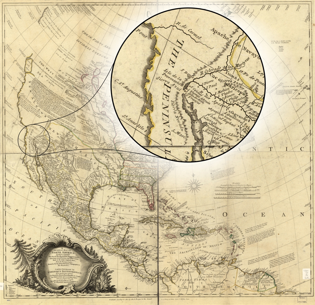
data:text/plain;charset=utf-8;base64, VGhlIG1hcCB3YXMgcHVibGlzaGVkIGFmdGVyIGhpcyBkZWF0aCBieSBoaXMgd2lmZSBNYXJ5IEFu biBSb2NxdWUuICBJdHMgb3JpZ2luYWwgdGl0bGUsIGFzIHdyaXR0ZW4gb24gdGhlIG1hcCBpcyBl eGFjdGx5IGFzIGZvbGxvd3M6IEEgZ2VuZXJhbCBtYXAgb2YgTm9ydGggQW1lcmljYTsgaW4gd2hp Y2ggaXMgZXhwcmVzcydkIHRoZSBzZXZlcmFsIG5ldyByb2FkcywgZm9ydHMsIGVuZ2FnZW1lbnRz LCAmYy4gdGFrZW4gZnJvbSBhY3R1YWwgc3VydmV5cyBhbmQgb2JzZXJ2YXRpb25zIG1hZGUgaW4g dGhlIGFybXkgZW1wbG95J2QgdGhlcmUsIGZyb20gdGhlIHllYXIgMTc1NCwgdG8gMTc2MS4gIFRo ZSBtYXAgd2FzIGEgY29tcGlsYXRpb24gb2Ygb3RoZXIgbWFwcyBhbmQgZGVzY3JpcHRpb25zIGZy b20gb3RoZXIgZXhwbG9yZXJzLiAgTXIuIFJvY3F1ZSBkaWQgbm90IG1ha2UgYW55IGZpcnN0IGhh bmQgb2JzZXJ2YXRpb25zIG9mIHdoYXQgaGUgZHJldy4NCg0KVGhlIGZvbGxvd2luZyBpbmZvcm1h dGlvbiBpcyBmcm9tIHRoZSBMaWJyYXJ5IG9mIENvbmdyZXNzOw0KDQpBIGdlbmVyYWwgbWFwIG9m IE5vcnRoIEFtZXJpY2E7IGluIHdoaWNoIGlzIGV4cHJlc3MnZCB0aGUgc2V2ZXJhbCBuZXcgcm9h ZHMsIGZvcnRzLCBlbmdhZ2VtZW50cywgJmMuIHRha2VuIGZyb20gYWN0dWFsIHN1cnZleXMgYW5k IG9ic2VydmF0aW9ucyBtYWRlIGluIHRoZSBhcm15IGVtcGxveSdkIHRoZXJlLCBmcm9tIHRoZSB5 ZWFyIDE3NTQsIHRvIDE3NjENCg0KQWJvdXQgdGhpcyBJdGVtDQoNClRpdGxlDQogICAgQSBnZW5l cmFsIG1hcCBvZiBOb3J0aCBBbWVyaWNhOyBpbiB3aGljaCBpcyBleHByZXNzJ2QgdGhlIHNldmVy YWwgbmV3IHJvYWRzLCBmb3J0cywgZW5nYWdlbWVudHMsICZjLiB0YWtlbiBmcm9tIGFjdHVhbCBz dXJ2ZXlzIGFuZCBvYnNlcnZhdGlvbnMgbWFkZSBpbiB0aGUgYXJteSBlbXBsb3knZCB0aGVyZSwg ZnJvbSB0aGUgeWVhciAxNzU0LCB0byAxNzYxOg0KQ29udHJpYnV0b3IgTmFtZXMNCiAgICBSb2Nx dWUsIEpvaG4sIC0xNzYyLiANCiAgICBEdXJ5LCBBbmRyZXcuIA0KICAgIFJvY3F1ZSAoTS4gQS4p IChGaXJtKSANCkNyZWF0ZWQgLyBQdWJsaXNoZWQNCiAgICBbTG9uZG9uLCBNLkEuIFJvY3F1ZSwg MTc2MT9dIA0KU3ViamVjdCBIZWFkaW5ncw0KICAgIC0gIE5vcnRoIEFtZXJpY2EtLU1hcHMtLUVh cmx5IHdvcmtzIHRvIDE4MDAgDQogICAgLSAgTm9ydGggQW1lcmljYSANCk5vdGVzDQogICAgLSAg U2NhbGUgY2EuIDE6OSw1MDAsMDAwLiANCiAgICAtICBIYW5kIGNvbG9yZWQuIA0KICAgIC0gIFJl bGllZiBzaG93biBwaWN0b3JpYWxseS4gDQogICAgLSAgU2hvd3MgQ2FyaWJiZWFuIHJlZ2lvbi4g DQogICAgLSAgIlB1Ymxpc2hlZCAuLi4gYnkgTS4gQS4gUm9jcXVlIGluIHRoZSBTdHJhbmQgJiBB LiBEdXJ5IGluIER1a2VzIENvdXJ0IFN0LiBNYXJ0aW5zIExhbmUuIiANCiAgICAtICBUaXRsZSBp biBFbmdsaXNoIGFuZCBGcmVuY2guIA0KICAgIC0gIExDIE1hcHMgb2YgTm9ydGggQW1lcmljYSwg MTc1MC0xNzg5LCA4OCANCiAgICAtICBJbmNsdWRlcyBoaXN0b3JpYyBhbmQgZGVzY3JpcHRpdmUg dGV4dC4gDQogICAgLSAgQXZhaWxhYmxlIGFsc28gdGhyb3VnaCB0aGUgTGlicmFyeSBvZiBDb25n cmVzcyBXZWIgc2l0ZSBhcyBhIHJhc3RlciBpbWFnZS4gDQogICAgLSAgVmF1bHQgDQogICAgLSAg QUFDUjI6IDEwMDsgNjUxOyA3MDAvMSANCk1lZGl1bQ0KICAgIGNvbC4gbWFwIDg3IHggOTEgY20u IA0KQ2FsbCBOdW1iZXIvUGh5c2ljYWwgTG9jYXRpb24NCiAgICBHMzMwMCAxNzYxIC5SNiANClJl cG9zaXRvcnkNCiAgICBMaWJyYXJ5IG9mIENvbmdyZXNzIEdlb2dyYXBoeSBhbmQgTWFwIERpdmlz aW9uIFdhc2hpbmd0b24sIEQuQy4gMjA1NDAtNDY1MCBVU0EgZGN1IA0KRGlnaXRhbCBJZA0KICAg IGh0dHA6Ly9oZGwubG9jLmdvdi9sb2MuZ21kL2czMzAwLmFyMDA4ODAwIA0KICAgIGh0dHA6Ly9o ZGwubG9jLmdvdi9sb2MuZ21kL2czMzAwLmFyMDA4ODAxIA0KTGlicmFyeSBvZiBDb25ncmVzcyBD b250cm9sIE51bWJlcg0KICAgIDc0NjkzODg2DQpMYW5ndWFnZQ0KICAgIEVuZ2ZyZQ0KICAgIEVu Z2xpc2gNCk9ubGluZSBGb3JtYXQNCiAgICBpbWFnZSANCkRlc2NyaXB0aW9uDQogICAgU2NhbGUg Y2EuIDE6OSw1MDAsMDAwLiBIYW5kIGNvbG9yZWQuIFJlbGllZiBzaG93biBwaWN0b3JpYWxseS4g U2hvd3MgQ2FyaWJiZWFuIHJlZ2lvbi4gIlB1Ymxpc2hlZCAuLi4gYnkgTS4gQS4gUm9jcXVlIGlu IHRoZSBTdHJhbmQgJiBBLiBEdXJ5IGluIER1a2VzIENvdXJ0IFN0LiBNYXJ0aW5zIExhbmUuIiBU aXRsZSBpbiBFbmdsaXNoIGFuZCBGcmVuY2guIExDIE1hcHMgb2YgTm9ydGggQW1lcmljYSwgMTc1 MC0xNzg5LCA4OCBJbmNsdWRlcyBoaXN0b3JpYyBhbmQgZGVzY3JpcHRpdmUgdGV4dC4gQXZhaWxh YmxlIGFsc28gdGhyb3VnaCB0aGUgTGlicmFyeSBvZiBDb25ncmVzcyBXZWIgc2l0ZSBhcyBhIHJh c3RlciBpbWFnZS4gVmF1bHQgQUFDUjI6IDEwMDsgNjUxOyA3MDAvMSANCkxDQ04gUGVybWFsaW5r DQogICAgaHR0cHM6Ly9sY2NuLmxvYy5nb3YvNzQ2OTM4ODYgDQpBZGRpdGlvbmFsIE1ldGFkYXRh IEZvcm1hdHMNCiAgICBNQVJDWE1MIFJlY29yZCANCiAgICBNT0RTIFJlY29yZCANCiAgICBEdWJs aW4gQ29yZSBSZWNvcmQgDQpJSUlGIFByZXNlbnRhdGlvbiBNYW5pZmVzdA0KICAgIE1hbmlmZXN0 IChKU09OL0xEKQ0KDQpBZGRpdGlvbmFsIEluZm9ybWF0aW9uOw0KDQpUaXRsZToNCiAgICBBIGdl bmVyYWwgbWFwIG9mIE5vcnRoIEFtZXJpY2EgOiBpbiB3aGljaCBpcyBleHByZXNzJ2QgdGhlIHNl dmVyYWwgbmV3IHJvYWRzLCBmb3J0cywgZW5nYWdlbWVudHMsICZjLCB0YWtlbiBmcm9tIGFjdHVh bCBzdXJ2ZXlzIGFuZCBvYnNlcnZhdGlvbnMgbWFkZSBpbiB0aGUgYXJteSBlbXBsb3knZCB0aGVy ZSwgZnJvbSB0aGUgeWVhcnMgMTc1NCwgdG8gMTc2MSANClRpdGxlIChhbHQuKToNCiAgICBDYXJ0 ZXMgZ2VuZXJhbGVzIGRlIGwnQW1lzIFyaXF1ZSBTZXB0ZW50cmlvbmFsZSA6IGVuIGxlcyBxdWVs bGVzIHNvbnQgZXhwcmltZcyAcyBsZXMgbm91dmVsbGVzIHJvdXRlcywgZm9ydHMsIGJhdGFpbGxl cywgJmMuIGQnYXByZcyAcyBsZXMgb2JzZXJ2YXRpb25zIHF1aSBvdSBldGXMgCBmYWl0ZXMgZGVw dWlzIGwnYW4gMTc1NCwganVzcXUnYSBsJ2FuIDE3NjENCkRlc2NyaXB0aW9uOg0KICAgIEZvbGxv d2luZyBoZXIgTG9uZG9uLWJhc2VkIGh1c2JhbmQgSm9obidzIGRlYXRoIGluIDE3NjIsIE1hcnkg QW5uIFJvY3F1ZSBhZG1pbmlzdGVyZWQgaGlzIGVzdGF0ZSBhbmQgY2FycmllZCBvbiBoaXMgbWFw IGJ1c2luZXNzIGZvciBzaXggeWVhcnMgYXMgdGhlIHB1Ymxpc2hlciBvZiBoaXMgd29ya3MuIFRo aXMgMTc2MSBtYXAgb2YgQW1lcmljYSBwdWJsaXNoZWQgYnkgIk0uQS4gUm9jcXVlIiB3YXMgcHJv dGVjdGVkIGJ5IGFuIEFjdCBvZiBQYXJsaWFtZW50LCBhcyBpdCBzdGF0ZXMgdW5kZXIgdGhlIGJv dHRvbSBuZWF0bGluZSwgbWVhbmluZyB0aGF0IGl0IHdhcyBjb3B5cmlnaHRlZCBhbmQgdGhlcmUg d2VyZSBwZW5hbHRpZXMgZm9yIHN0ZWFsaW5nIHRoZSBkZXNpZ24gYW5kIHJldXNpbmcgaXQgdW5k ZXIgYW5vdGhlciBuYW1lLiBNYXJ5IEFubiBzb21ldGltZXMgdXNlZCBoZXIgaW5pdGlhbHMgaW4g dGhlIGltcHJpbnQsIGFzIG9uIHRoaXMgbWFwLiBDb25zZXF1ZW50bHksIG11Y2ggb2YgaGVyIHdv cmsgd2FzIHVucmVjb2duaXplZCBhcyB0aGF0IHByb2R1Y2VkIGJ5IGEgd29tYW4gaW4gdGhlIG1h cCB0cmFkZS4NCkNyZWF0b3I6DQogICAgUm9jcXVlLCBKb2huLCBkLiAxNzYyDQpDcmVhdG9yOg0K ICAgIER1cnksIEFuZHJldy4NCkNyZWF0b3I6DQogICAgUm9jcXVlIChNLiBBLikgKEZpcm0pDQpO YW1lIG9uIEl0ZW06DQogICAgZHJhd24gYnkgdGhlIGxhdGUgSm9obiBSb2NxdWUsIHRvcG9ncmFw aGVyIHRvIGhpcyBtYWplc3R5Lg0KRGF0ZToNCiAgICBbMTc2Ml0NCkZvcm1hdDoNCiAgICBNYXBz L0F0bGFzZXMNCkxvY2F0aW9uOg0KICAgIEJvc3RvbiBQdWJsaWMgTGlicmFyeQ0KICAgIE5vcm1h biBCLiBMZXZlbnRoYWwgTWFwIENlbnRlciANCkNvbGxlY3Rpb24gKGxvY2FsKToNCiAgICBOb3Jt YW4gQi4gTGV2ZW50aGFsIE1hcCBDZW50ZXIgQ29sbGVjdGlvbg0KU3ViamVjdHM6DQogICAgTm9y dGggQW1lcmljYS0tTWFwcy0tRWFybHkgd29ya3MgdG8gMTgwMA0KICAgIFVuaXRlZCBTdGF0ZXMt LUhpc3RvcnktLUZyZW5jaCBhbmQgSW5kaWFuIFdhciwgMTc1NC0xNzYzLS1NYXBzLS1FYXJseSB3 b3JrcyB0byAxODAwDQpQbGFjZXM6DQogICAgTm9ydGggQW1lcmljYSAoYXJlYSkNCiAgICBVbml0 ZWQgU3RhdGVzDQpQdWJsaXNoZXI6DQogICAgTG9uZG9uIDogcHVibGlzaGVkIGFjb3JkaW5nIHRv IHRoZSBhY3QgYnkgTS5BLiBSb2NxdWUgLi4uICYgQS4gRHVyeQ0KTm90ZXM6DQogICAgUmVsaWVm IHNob3duIHBpY3RvcmlhbGx5Lg0KICAgIElkZW50aWZpZXMgcHJlLSBhbmQgcG9zdC13YXIgYm91 bmRhcmllcy4NCiAgICBUaXRsZSBpbiBGcmVuY2ggYW5kIEVuZ2xpc2guDQogICAgRXhoaWJpdGVk OiAiV29tZW4gaW4gQ2FydG9ncmFwaHk6IEZpdmUgQ2VudHVyaWVzIG9mIEFjY29tcGxpc2htZW50 cyIgb3JnYW5pemVkIGJ5IHRoZSBOb3JtYW4gQi4gTGV2ZW50aGFsIE1hcCBDZW50ZXIgYXQgdGhl IEJvc3RvbiBQdWJsaWMgTGlicmFyeSwgMjAxNS0yMDE2Lg0KRXh0ZW50Og0KICAgIDEgbWFwIG9u IDIgc2hlZXRzIDogaGFuZCBjb2wuIDsgODUgeCA4OSBjbS4sIG9uIHNoZWV0cyA1NCB4IDk4IGNt LiANClNjYWxlOg0KICAgIFNjYWxlIFtjYS4gMTo5LDUwMCwwMDBdDQpMYW5ndWFnZToNCiAgICBF bmdsaXNoDQogICAgRnJlbmNoDQpJZGVudGlmaWVyOg0KICAgIDA2XzAxXzAwNDEzMA0KQ2FsbCAj Og0KICAgIEczMzAwIDE3NjIgLlI2Mw0KQmFyY29kZToNCiAgICAzOTk5OTA1OTAwNDA5MQ0KVGVy bXMgb2YgVXNlOg0KICAgIE5vIGtub3duIGNvcHlyaWdodCByZXN0cmljdGlvbnMuDQogICAgTm8g a25vd24gcmVzdHJpY3Rpb25zIG9uIHVzZS4=
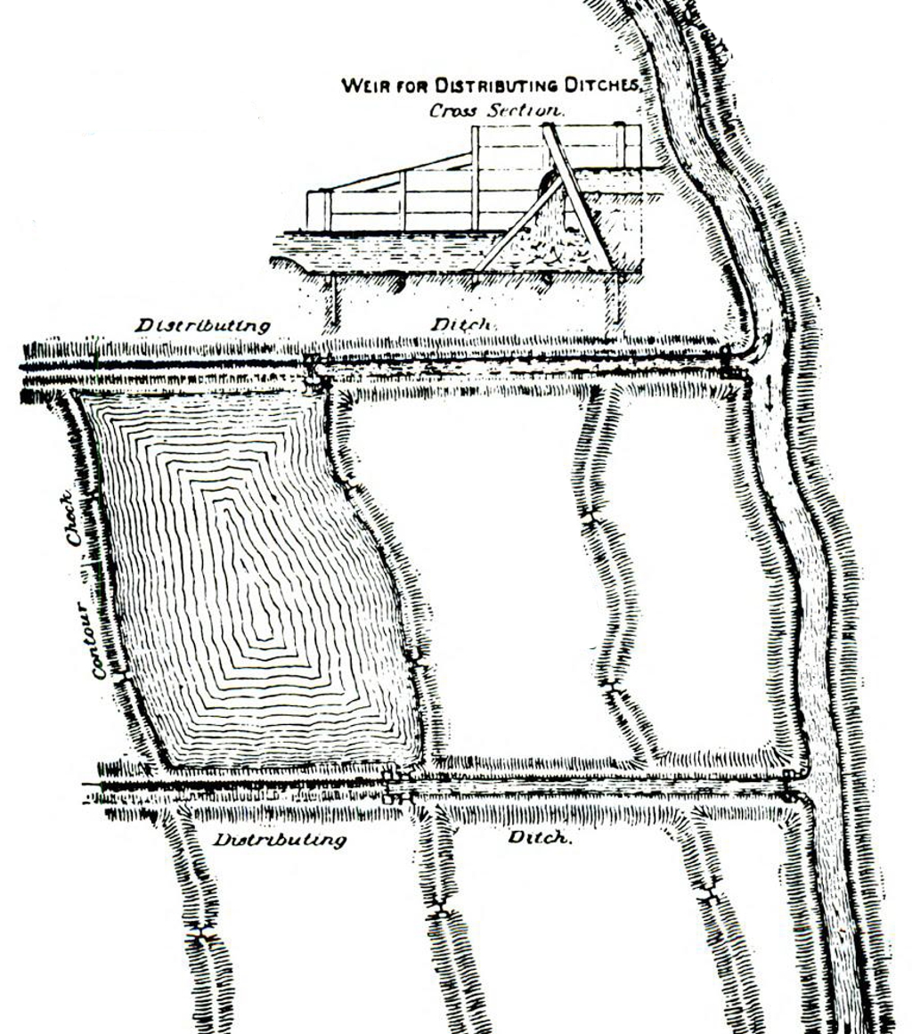
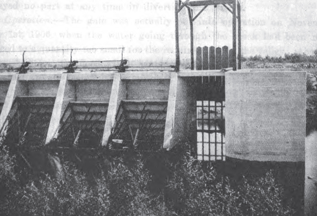
data:text/plain;charset=utf-8;base64, ZGF0YTp0ZXh0L3BsYWluO2NoYXJzZXQ9dXRmLTg7YmFzZTY0LA0KDQpUaGUgaW1hZ2Ugc2hvd3Mg YSB3YXRlciBzb3VyY2UgZGl2ZXJ0ZWQgZnJvbSBhIHJpdmVyIGFuZCBjb250cm9sbGVkIGJ5IGEg d2VpciAoZGFtKS4gIEl0IGNvbnNpc3RzIG9mIGEgc2VyaWVzIG9mIGRpdGNoZXMgYW5kIGNhbmFs cyBsYWlkIG91dCBpbiBhIGdyaWQgbGlrZSBwYXR0ZXJuLCBtb3N0IGNvbW1vbiBpbiByZWdpb25z IHRoYXQgYXJlIGZsYXQgYW5kIGRvIG5vdCBoYXZlIHRvIGNvbnNpZGVyIHRoZSBjb250b3VycyBv ZiB0aGUgbGFuZC4gIFRoZXNlIGRpdGNoZXMgYW5kIGNhbmFscyBhcmUgaW50ZXJjb25uZWN0ZWQg YW5kIGRpc3RyaWJ1dGUgd2F0ZXIgdG8gY3JvcHMuICBDb250b3VyIGxpbmVzIGFyZSBzaG93biBv biBvbmUgc2VjdGlvbiB0aGF0IHNob3cgdGhlIGNlbnRlciBvZiB0aGUgZmllbGRzIHRoYXQgYXJl IGlycmlnYXRlZCBhcyBsb3dlciB0aGFuIHRoZSBlZGdlcy4gIFRoaXMgaXMgZGlmZmVyZW50IGZy b20gbW9kZXJuIGlycmlnYXRpb24gd2hpY2ggdXNlcyBwYXJhbGxlbCBjaGFubmVscyB0byBkaXN0 cmlidXRlIHdhdGVyLiAgQSBjcm9zcyBzZWN0aW9uIG9mIGEgd2VpciAoZGFtKSBpcyBhbHNvIHNo b3duLCB3aGljaCBpbGx1c3RyYXRlcyBhIHNtYWxsIGRyb3AgaW4gZWxldmF0aW9uIGJldHdlZW4g dGhlIHNvdXJjZSBvZiB0aGUgd2F0ZXIgYW5kIHRoZSBtYWluIGRpc3RyaWJ1dGlvbiBjaGFubmVs IGFsb25nIHdpdGggYSBiYXNpYyBjb250cm9sIHN5c3RlbSBmb3IgbWV0ZXJpbmcgdGhlIHdhdGVy IGZsb3cuDQoNClRoZSBvcmlnaW5hbCB0ZXh0LCBmcm9tIFJlcG9ydCBvZiB0aGUgU3BlY2lhbCBD b21taXR0ZWUgb2YgdGhlIFVuaXRlZCBTdGF0ZXMgU2VuYXRlIG9uIHRoZSBJcnJpZ2F0aW9uIGFu ZCBSZWNsYW1hdGlvbiBvZiBBcmlkIExhbmRzIDE4OTA6IFRoaXMgbWFwIHNob3dzIHRoYXQgcG9y dGlvbiBvZiB0aGUgcHJvcGVydHkgaW4gS2VybiBDb3VudHksIENhbC4sIGx5aW5nIHRvIHRoZSBu b3J0aCBvZiBLZXJuIFJpdmVyIGFuZCB0byB0aGUgd2VzdCAwIHRoZSBTb3V0aGVybiBQYWNpZmlj IFJhaWxyb2FkLCB3aGljaCBKLiBCLkhhZ2dpbiBhbmQgaGlzIGFzc29jaWF0ZXMgaGF2ZSBhbHJl YWR5IHJlY2xhaW1lZCwgYW5kIGFyZSBub3cgaW4gcHJvY2VzcyBvZiByZWNsYWltaW5nICwgZnJv bSBhbiBhcmlkLCB1bnByb2R1Y3RpdmUgc3RhdGUsIGJ5IG1lYW5zIG9mIGlycmlnYXRpb24uIFRo ZSBzaGFkZWQgbGluZXMgaW5kaWNhdGUgdGhlIGxhdWRzIG93bmVkIGJ5IHRoZSBwYXJ0aWVzIGRp cmVjdGx5IGludGVyZXN0ZWQgaW4gdGhpcyB3b3JrIG9mIHJlY2xhbWF0aW9uIGFuZCBpcnJpZ2F0 aW9uLCBhbmQgd2hvIGFsc28gb3duIHRoZSBuZXQtd29yayBvZiBkaXRjaGVzIHRocm91Z2ggd2hp Y2ggc3VjaCByZXN1bHRzIGhhdmUgYmVlbiBhbmQgYXJlIHRvIGJlIGVmZmVjdGVkLiBBbiBpZGVh IG9mIHRoZSBtYWduaXR1ZGUgb2YgdGhlc2Ugb3BlcmF0aW9ucyBjYW4gYmUgb2J0YWluZWQgZnJv bSB0aGlzIG1hcCwga2VlcGluZyBpbiBWaWV3IHRoYXQgdGhlIGxlbmd0aCBhbHJlYWR5IGNvbnN0 cnVjdGVkIG9mIHRoZSBDYWxsb3dheSBDYW5hbCBhbW91bnRzIHRvIDMyIG1pbGVzLCBhbmQgdGhh dCBhbiBleHRlbnNpb24gaXMgaW4gY29udGVtcGxhdGlvbiBvZiAxMSBhZGRpdGlvbmFsIG1pbGVz IHRvIGJlIG9mIHRoZSBzYW1lIHNpemUgYXMgdGhlIHByZXNlbnQgY2FuIGFsLCBuYW1lbHkgODAg ZmVldCB3aWRlIG9uIHRoZSBib3R0b20gYW5kIDEyMCBmZWV0IHdpZGUgZnJvbSBiYW5rIHRvIGJh bmsuIEluIHRoZSDigJxiaXJk4oCZcy1leWUgdmlld+KAnSBhcmUgc2hvd24gdGhlIHJpdmVyLCBh IHBvcnRpb24gb2YgdGhlIENhbGxvd2F5IENhbmFsLCB0d28gZGlzdHJpYnV0aW5nIGRpdGNoZXMs IGFuZCBzZXZlcmFsIGNvbnRvdXIgY2hlY2tzLiBBcyBpbmRpY2F0ZWQgYnkgdGhlIGFycm93cywg dGhlIHdhdGVyIGluIHRoZSByaXZlciwgYXJyZXN0ZWQgYnkgdGhlIHdlaXIsIGVudGVycyB0aGUg Q2FsbG93YXkgQ2FuYWwgdGhyb3VnaCBpdHMgaGVhZC1nYXRlIGFuZCBmcm9tIHRoZW5jZSBwYXNz ZXMgaW50byB0aGUgZGlzdHJpYnV0aW5nIGRpdGNoZXMuIGxuIHRoZSBsYXR0ZXIgYXJlIHNob3du IHRoZSDigJwgZHJvcHMs4oCdIGFjdGluZyBzaW1pbGFybHkgdG8gdGhlIHJpdmVyIHdlaXIsIGFu ZCBmb3JjaW5nIHRoZSB3YXRlciBvdXQgb2YgdGhlIGRpc3RyaWJ1dGluZyBkaXRjaGVzIHRocm91 Z2ggdGhlIOKAnHNpZGUgZ2F0ZXPigJ0gb2YgdGhvc2UgZGl0Y2hlcyBvbnRvIHRoZSBsYW5kIGVu Y2xvc2VkIGJ5IHRoZSBjb250b3VyIGNoZWVrcywgdGh1cyBhY2NvbXBsaXNoaW5nIHRoZSBhY3R1 YWwgaXJyaWdhdGlvbi4gIEluIHRoZSDigJxwbGFuIG9mIGlycmlnYXRpb27igJ0gYXJlIHNpbWls YXJseSBzaG93biBhIHBvcnRpb24gb2YgdGhlIENhbGxvd2F5IENhbmFsLCBkaXN0cmlidXRpbmcg ZGl0Y2hlcywgYW5kIGNoZWNrcywgdG9nZXRoZXIgd2l0aCBjcm9zcy1zZWN0aW9ucyBvZiB0aGUg R2FsbG93YXkgZGlzdHJpYnV0aW5nIGRpdGNoIGFuZCBvZiBsYW5kIGluIHByb2Nlc3Mgb2YgaXJy aWdhdGlvbi4gVGhlIGNoZWNrcyBhcmUgcnVuIG9uIGEgbGV2ZWwsIGFuZCB0aHVzIGF0IHJlZ3Vs YXIgaW50ZXJ2YWxzIG9mIDYsIDksMTIsIDE4LCBvciAyNCBpbmNoZXMsIGFzIGRlc2lyZWQsIGFj dCBhcyBkYW1zIHRvIGJhY2sgdGhlIHdhdGVyIG92ZXIgdGhlIHNwYWNlIGludGVydmVuaW5nIGJl dHdlZW4gdGhlIGNoZWNrIHNvIGNvbnN0aXR1dGluZyB0aGUgZGFtIGFuZCB0aGUgbmV4dCBjaGVj ayBhYm92ZSwgYXMgYXBwZWFyaW5nIGluIHRoZSBjcm9zcy1zZWN0aW9uLiBXaGVuIHRoZSBpcnJp Z2F0aW9uIGluIG9uZSBjaGVjayBpcyBjb21wbGV0ZWQgdGhlIHN1cnBsdXMgd2F0ZXIgZnJvbSB0 aGF0IGNoZWNrIGlzIGRyYWluZWQgaW50byB0aGUgbmV4dCBjaGVjayBiZWxvdywgdGhlIGJhbGFu Y2Ugb2YgdGhlIHdhdGVyIHJlcXVpcmVkIGJlaW5nIHN1cHBsaWVkIGZyb20gdGhlIGRpc3RyaWJ1 dGluZyBkaXRjaC4gLFN1Y2ggaXMgdGhlIHN5c3RlbSBvZiBpcnJpZ2F0aW9uIG1vc3QgZ2VuZXJh bCBpbiBLZXJuIENvdW50eSwgYW5kIGZyb20gaXRzIGNoZWFwbmVzcyBvZiBjb25zdHJ1Y3Rpb24g YXMgY29tcGFyZWQgd2l0aCBvdGhlciBzeXN0ZW1zIGFuZCB0aGVpciByZXN1bHRzLCBpdHMgZXh0 cmVtZSBjaGVhcG5lc3Mgb2Ygb3BlcmF0aW9uLCBpdHMgbW9zdCBzYXRpc2ZhY3RvcnkgcmVzdWx0 cyBpbiB0aGUgZXZlbiBhbmQgdGhvcm91Z2ggZGlzdHJpYnV0aW9uIG9mIHRoZSB3YXRlciwgcmVz dWx0aW5nIGluIHRob3JvdWdoIGlycmlnYXRpb24gYW5kIHByb2ZpdGFibGUgcmV0dXJucywgaXQg Y29tbWVuZHMgaXRzZWxmIGZvciBzaW11bHRhbmVvdXMgaXJyaWdhdGlvbiBvZiBsYXJnZSBhcmVh cyBtb3N0IHN0cm9uZ2x5IGFzIHdvcnRoeSBvZiBhIGZvcmVtb3N0IHBsYWNlIGluIGlycmlnYXRp b24gc3lzdGVtcy4=
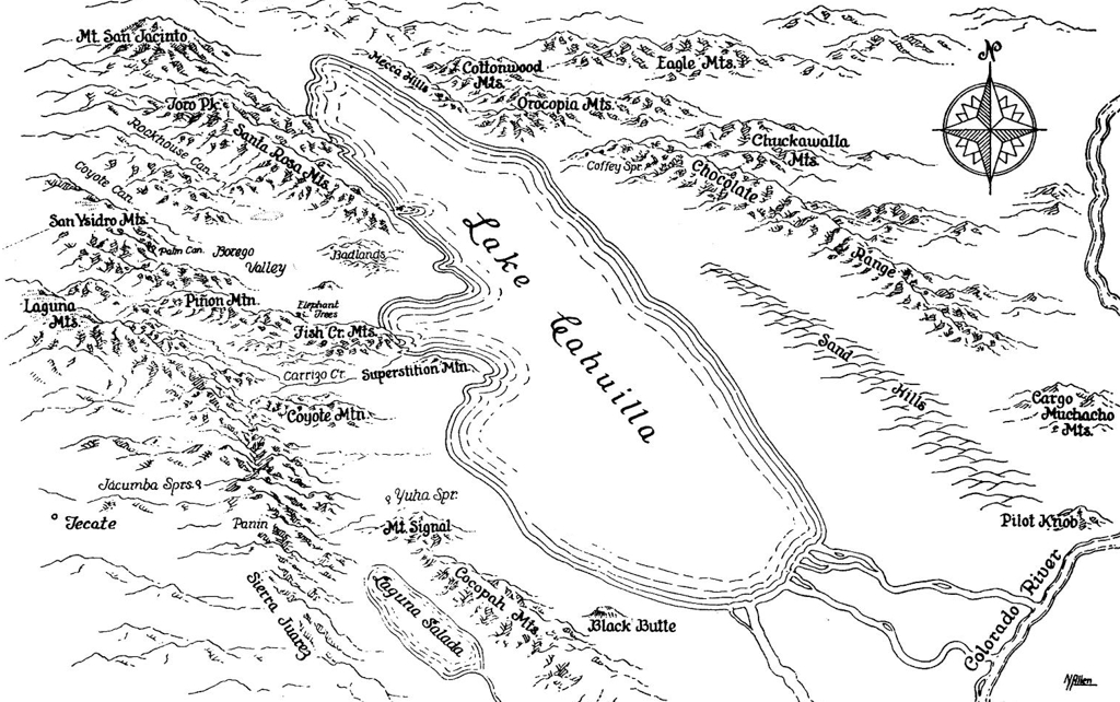
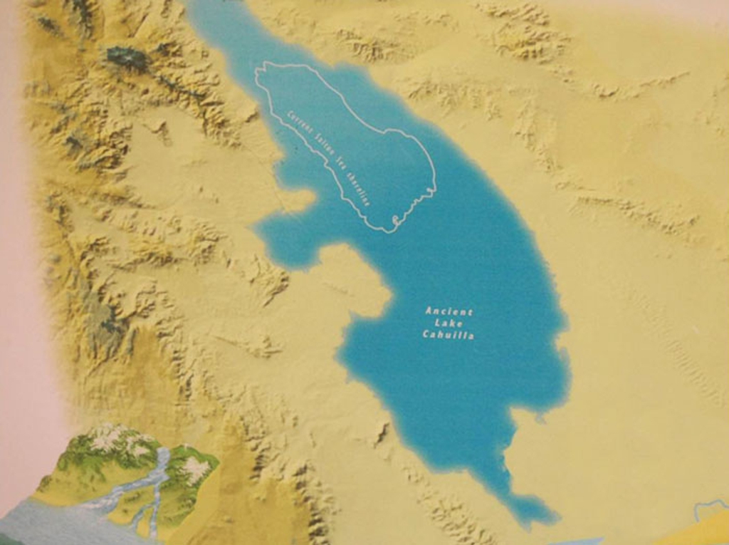
data:text/plain;charset=utf-8;base64, VGhpcyBtYXAgZGVwaWN0cyBMYWtlIENhaHVpbGxhIGFzIGl0IGV4aXN0ZWQgbWFueSB0aW1lcyBp biB0aGUgZGlzdGFudCBwYXN0IGluIHRoZSBzYW1lIHJlZ2lvbiB3aGVyZSB0aGUgU2FsdG9uIFNl YSBleGlzdHMgdG9kYXkuICBUaGUgbGFrZSBpcyBtdWNoIGxhcmdlciwgYXQgaXRzIGNhcGNpdHks IG9jY3VweWluZyB0aGUgZW50aXJlIFNhbHRvbiBUcm91Z2guICBJdCBpcyByb3VnaGx5IDUgdGlt ZXMgdGhlIHN1cmZhY2UgYXJlYSwgNCB0aW1lcyB0aGUgZGVwdGgsIGFuZCBhYm91dCAxMDAgdGlt ZXMgdGhlIHZvbHVtZSB0aGFuIHRoZSBzZWEuDQoNCldhdGVyIGZyb20gdGhlIENvbG9yYWRvIFJp dmVyIHRvIHRoZSBzb3V0aCBpcyBzaG93biBmbG93aW5nIHdlc3QsIG5vcnRod2VzdCwgaW50byB0 aGUgU2FsdG9uIFNpbmsgYW5kIExha2UgQ2FodWlsbGEsIHRoZW4gZmxvd2luZyBvdXQgb2YgdGhl IGludG8gdGhlIEd1bGYgb2YgQ2FsaWZvcm5pYSAvIFNlYSBvZiBDb3J0ZXogdG8gdGhlIHNvdXRo LCBzb3V0aHdlc3QuICBUaGUgTGFndW5hIFNhbGFkYSwgYW5vdGhlciByZWdpb24gdG8gdGhlIHNv dXRod2VzdCBvZiB0aGUgbGFrZSwgYWxzbyBiZWxvdyBzZWEgbGV2ZWwsIGZpbGxlZCB3aXRoIHdh dGVyIHRvby4gIEl0cyBzb3VyY2Ugb2Ygd2F0ZXIgaXMgbm90IHNob3duIG9uIHRoZSBtYXAsIGJ1 dCBpcyBmcm9tIGEgdHJpYnV0YXJ5IG9mIHRoZSBvdXRmbG93IG9mIHRoZSBsYWtlIGFzIGl0IG1h a2VzIGl0cyB3YXkgdG8gdGhlIGd1bGYuDQoNClRoZSBtYXAgaW5jbHVkZXMgc3Vycm91bmRpbmcg bW91bnRhaW4gcmFuZ2VzLCBpbmNsdWRpbmcgUGlsb3QgS25vYiwgdGhhdCBkZW1vbnN0cmF0ZSBo b3cgdGhlIGxha2UgaXMgc3Vycm91bmRlZCBvbiB0aGUgd2VzdCwgbm9ydGgsIGFuZCBlYXN0IGJ5 IG11Y2ggaGlnaGVyIGVsZXZhdGlvbnMuICBUaGUgbmFtZXMgb2YgdGhlIG1vdW50YWlucyBpcyBp biBhIHRleHQgc2ltaWxhciB0byBjYWxpZ3JhcGh5LiANCg0KVGhlcmUgaXMgYWxzbyBjb21wYXNz IHJvc2Ugb24gdGhlIHRvcCByaWdodCBvZiB0aGUgbWFwIHNob3dpbmcgbm9ydGguICBUaGUgYXV0 aG9yJ3MgaW1hZ2Ugc2lnbmF0dXJlLCBpbiBpdHMgaW5pdGlhbCBmb3JtIG9mIE5BbGxlbiwgaXMg b24gdGhlIGJvdHRvbSByaWdodCBpbiBoaXMgdHlwaWNhbCBzdHlsZSwgd2hpY2ggaXMgcmVtZW5p Y2VudCBvZiBhIE1ldHJvcG9saXMgKG1vdmllKSBzdHlsZS4NCg0KVGhlIG1hcCB3YXMgZHJhd24g YnkgYXJ0aXN0IExhd3JlbmNlIE5vcnRvbiBBbGxlbiBhbmQgb3JpZ2luYWxseSBwdWJsaXNoZWQg d2lkZWx5IGluIHRoZSBOb3ZlbWJlciAxOTYwIGlzc3VlIG9mIERlc2VydCBNYWdhemluZS4gIE5v cnRvbiBMYXdyZW5jZSBBbGxlbiB3YXMgYm9ybiBKYW51YXJ5IDYsIDE5MDkgYW5kIGRpZWQgTWF5 IDI0LCAxOTk3LiAgSGUgcHVibGlzaGVkIG1hbnkgc2tldGNoZXMgZHVyaW5nIHRoZSBlYXJseSAy MHRoIGNlbnR1cnkgd2l0aCBtYW55IHB1Ymxpc2hlZCBpbiBEZXNlcnQgTWFnYXppbmUgc3RhcnRp bmcgaW4gMTkzNy4gIEEgZnVsbCBCaW9ncmFwaHkgY2FuIGJlIGZvdW5kIGhlcmU6IGh0dHBzOi8v d3d3LmpzdG9yLm9yZy9zdGFibGUvMjc5MjAyMTY/cmVhZC1ub3c9MSZyZWZyZXFpZD1leGNlbHNp b3IlM0EzMWVlYWJiYTg3ZjI4ZGJkNTE1ZDQwN2U0MWE0YTQxOSZzZXE9MzkjcGFnZV9zY2FuX3Rh Yl9jb250ZW50cyAgQW4gaW50ZXJlc3RpbmcgaW52ZXN0aWdhdGlvbiBvbiBoaXMgbGlmZSBjYW4g YmUgZm91bmQgaGVyZTogaHR0cHM6Ly93d3cua2NldC5vcmcvc2hvd3MvYXJ0Ym91bmQvbm9ydG9u LWFsbGVuLXRyYWNraW5nLXRoZS1lbHVzaXZlLW1hcG1ha2VyLiAgVGhlIERpc25leSBtb3ZpZSBD YXJzIHVzZXMgYSBtYXAgb2YgUmFkaWF0b3IgU3ByaW5ncyBhbmQgdGhlIHN1cnJvdW5kaW5nIGFy ZWEgYXQgdGhlIGJlZ2lubmluZyBvZiB0aGUgZW5kIGNyZWRpdHMgdGhhdCBpcyBkZXJpdmVkIG9y IHNvdXJjZWQgb3IgZHJhd24gaW4gb3IgcmVtaW5pc2NlbnQgb2YgaGlzIHN0eWxlLg==
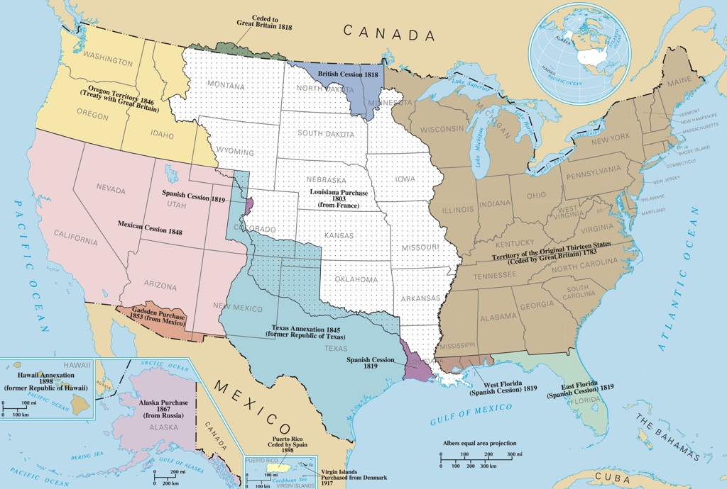
data:text/plain;charset=utf-8;base64, VGhlIHRlcnJpdG9yaWVzIG9idGFpbmVkIGJ5IHRoZSBVbml0ZWQgU3RhdGVzIHdlcmUgdGhyb3Vn aCBwdXJjaGFzZSwgZ3JhbnRzLCBvciBjb25xdWVzdC4gIE9uIHRoZSBlYXN0IGNvYXN0IGFyZSB0 aGUgMTMgb3JpZ2luYWwgY29sb25pZXMsIERlbGF3YXJlLCBQZW5uc3lsdmFuaWEsIE5ldyBKZXJz ZXksIEdlb3JnaWEsIENvbm5lY3RpY3V0LCBNYXNzYWNodXNldHRzIEJheSwgTWFyeWxhbmQsIFNv dXRoIENhcm9saW5hLCBOZXcgSGFtcHNoaXJlLCBWaXJnaW5pYSwgTmV3IFlvcmssIE5vcnRoIENh cm9saW5hLCBhbmQgUmhvZGUgSXNsYW5kIGFuZCBQcm92aWRlbmNlIFBsYW50YXRpb25zLCB3ZXJl IG9idGFpbmVkIHZpYSBjZXNzaW9uIGZyb20gR3JlYXQgQnJpdGFpbiBpbiAxNzgzLCB3aXRoIHN0 YXRlaG9vZCBncmFudGVkIHNldmVyYWwgeWVhcnMgbGF0ZXIuICBUZW5uZXNzZWUsIFdlc3QgVmly Z2luaWEsIE9oaW8sIEFsYWJhbWEsIE1pc3Npc2lwcGksIEtlbnR1Y2t5LCBJbGxpbm9pcywgV2lz Y29uc29uLCBNaWNoaWdhbiwgYW5kIHBhcnRzIG9mIE1pbm5lc290YSB3ZXJlIG9idGFpbmVkIG92 ZXIgYSBwZXJpb2Qgb2YgeWVhcnMgaW4gdGhlIGVhcmx5IDE4MDBzLiAgVGhlIExvdWlzaWFuYSBQ dXJjaGFzZSBtYWRlIGluIDE4MDMgaW5jbHVkZWQgdGVycml0b3J5IGluIHRoZSBjZW50cmFsIHBh cnQgb2YgdGhlIGN1cnJlbnQgVW5pdGVkIFN0YXRlcy4gIFRoZSB0ZXJyaXRvcnkgY29tcHJpc2Vz IHNldmVyYWwgbW9kZXJuIHN0YXRlcyBpbmNsdWRpbmcgTG91aXNpYW5hLCBBcmthbnNhcywgTWlz c291cmksIElvd2EsIE1pbm5lc290YSwgT2tsYWhvbWEsIEthbnNhcywgTmVicmFza2EsIFNvdXRo IERha290YSwgTm9ydGggRGFrb3RhLCBUZXhhcywgTmV3IE1leGljbywgQ29sb3JhZG8sIFd5b21p bmcsIGFuZCBNb250YW5hLiBJbiB0aGUgc291dGhlYXN0LCB0ZXJyaXRvcmllcyBmcm9tIFNwYWlu IHdlcmUgb2J0YWluZWQgaW4gMTgxOSB3aGljaCBpbmNsdWRlIEZsb3JpZGEsIHBhcnRzIG9mIEFs YWJhbWEsIE1pc3Npc3NpcHBpLCBhbmQgTG91aXNpYW5hLiAgT3RoZXIgdGVycml0b3J5IHRvIHRo ZSB3ZXN0LCBpbmNsdWRlIG1vZGVybiBzdGF0ZXMgc3VjaCBhcyBUZXhhcywgTmV3IE1leGljbywg Q29sb3JhZG8sIFd5b21pbmcsIElkYWhvLCBBcml6b25hLCBVdGFoLCBOZXZhZGEsIE9yZWdvbiwg V2FzaGluZ3RvbiwgYW5kIENhbGlmb3JuaWEgd2VyZSBvYnRhaW5lZCBmcm9tIE1leGljbywgU3Bh aW4sIGFuZCBHcmVhdCBCcml0YWluIGJldHdlZW4gMTgxOSBhbmQgMTg1My4gIFRoZSBjdXJyZW50 IHN0YXRlIG9mIEFsYXNrYSB3YXMgcHVyY2hhc2VkIGZyb20gUnVzc2lhIGluIDE4NjcuICBIYXdh aWkgd2FzIGFubmV4ZWQgaW4gMTg5OC4gIFRoZSBWaXJnaW4gSXNsYW5kcyB3ZXJlIHB1cmNoYXNl ZCBmcm9tIERlbm1hcmsgaW4gMTkxNy4gIFRoZXJlIGFyZSBzZXZlcmFsIG90aGVyIHRlcnJpdG9y aWVzIHN1Y2ggYXMgQW1lcmljYW4gU2Ftb2EsIEd1YW0sIE5vcnRoZXJuIE1hcmlhbmEgSXNsYW5k cywgYW5kIFB1ZXJ0byBSaWNvIGFyZSBhZGRyZXNzZWQgYnkgdGhpcyBtYXAuICBBIHNtYWxsIGlu c2V0IG1hcCBvZiB0aGUgR2xvYmUgc2hvd3MgdGhlIHBvc2l0aW9uIG9mIHRoZSBVbml0ZWQgU3Rh dGVzIGluIHJlbGF0aW9uc2hpcCB0byBvdGhlciBjb3VudHJpZXMgYW5kIG9jZWFucy4NCg0KUGxl YXNlIG5vdGUsIHRoaXMgbWFwIGRvZXMgbm90IGF0dGVtcHQgdG8gYWRkcmVzcyB0aGUgdmFyaW91 cyBpbmp1c3RpY2VzIGltcG9zZWQgdXBvbiBOYXRpdmUgQW1lcmljYW4gcGVvcGxlIG9yIG90aGVy cy4gSXQgc2ltcGx5IGRpc3BsYXlzIHRoZSBkYXRlcywgZ2VvZ3JhcGhpYyByZWdpb25zLCBhbmQg d2VsbCBrbm93IHRpdGxlcyBhc3NvY2lhdGVkIHdpdGggZXZlbnRzLg0KDQpBcmVhcyBub3Qgc2hv d24gaW5jbHVkZSBHdWFtLCBOb3J0aGVybiBNYXJpYW5hIElzbGFuZHMsIEFtZXJpY2FuIFNhbW9h LCBhbmQgb3RoZXIgb3V0bHlpbmcgaXNsYW5kcywgZm9ybWVyIHRlcnJpdG9yaWVzLg0KDQpJbmZv cm1hdGlvbiBmcm9tIE9yaWdpbmFsIFNvdXJjZTogVGhlIE5hdGlvbmFsIEF0bGFzIG9mIHRoZSBV bml0ZWQgU3RhdGVzIERlcGFydG1lbnQgb2YgdGhlIEludGVyaW9yLCBlZGl0ZWQgb3IgY3JlYXRl ZCBjaXJjYSAyMDAwcy4NCg==

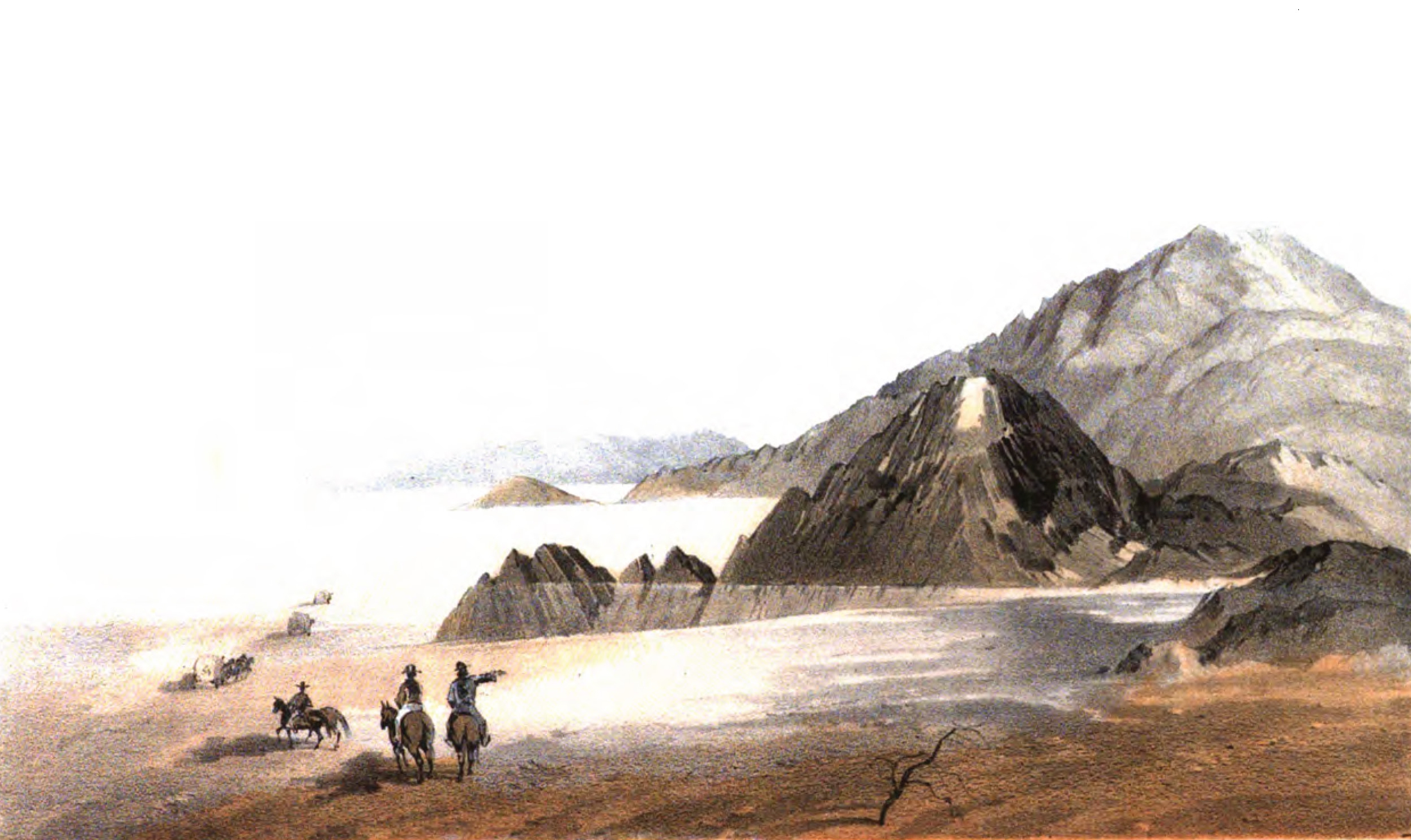
data:text/plain;charset=utf-8;base64, VGhpcyBjb2xvciBkcmF3aW5nIHdhcyBza2V0Y2hlZCBieSBXaWxsaWFtIFBoaXBwcyBCbGFrZSBv biBOb3ZlbWJlciAxNSwgMTg1MyBsb29raW5nIHNvdXRoLCBzb3V0aGVhc3QgaW50byB0aGUgQ29s b3JhZG8gRGVzZXJ0LiAgSXQgZGVwaWN0cyBoZSBhbmQgaGlzIHBhcnR5IGFzIHRoZXkgd2VyZSBk ZXNjZW5kaW5nIHRocm91Z2ggdGhlIG5vcnRoZXJuIHNlY3Rpb24gb2Ygd2hhdCBpcyBub3cga25v d24gYXMgdGhlIENvYWNoZWxsYSBWYWxsZXkuICBTZXZlcmFsIHJpZGVycyBvbiBob3JzZWJhY2sg Y2FuIGJlIHNlZW4gYWxvbmcgd2l0aCBzZXZlcmFsIGNvdmVyZWQgd2Fnb25zIGJlaW5nIGRyYXdu IGJ5IHRlYW1zIG9mIHdoYXQgYXBwZWFyIHRvIGJlIGZvdXIgaG9yc2VzIGZvciBlYWNoIHdhZ29u LiAgSW4gaGlzIGJvb2sgb2YgdGhlc2UgZXZlbnRzIGhlIGRlc2NyaWJlcyBtdWxlcyBkcmlua2lu ZyB3YXRlciwgc28gaXQgbWF5IGJlIHRoYXQgd2hhdCBhcHBlYXIgdG8gYmUgaG9yc2VzIGFyZSBh Y3R1YWxseSBtdWxlcy4gIFRoZSBkZXNlcnQgaW4gZnJvbnQgb2YgdGhlbSBpcyBwaWN0dXJlZCBh cyBhIHdhc2hlZCBvdXQgYW5kIGZhZGVkIHdoaXRlLiAgQmxlYWsgbW91bnRhaW5zIHRvIHRoZSB3 ZXN0IGNhbiBiZSBzZWVuIChub3QgcGljdHVyZWQgYXJlIHRoZSBDaG9jb2xhdGUgTW91bnRhaW5z IHRvIHRoZSB3ZXN0KSBhbG9uZyB3aXRoIGFkZGl0aW9uYWwgbW91bnRhaW5zIGluIHRoZSBkaXN0 YW5jZSB0byB0aGUgc291dGgsIHNvdXRod2VzdC4gIFRoZSBtb3VudGFpbnMgdG8gdGhlIHJpZ2h0 data:text/plain;charset=utf-8;base64, IHNob3cgYSBzbG9waW5nIGxhbmRzY2FwZSBpbiBmcm9udCBvZiB0aGVtIHRvIGlsbHVzdHJhdGUg dGhleSB3ZXJlIGRlc2NlbmRpbmcgZG93biBhIHNsb3BlLCBhbHRob3VnaCBpdCBzZWVtcyB0byBi ZSBzbGlnaHRseSBleGFnZ2VyYXRlZCBmb3IgaWxsdXN0cmF0aW9uIHB1cnBvc2VzIGNvbXBhcmVk IHRvIHRoZSBzbG9wZSBvZiB0aGUgYWN0dWFsIGxhbmQuDQoNCk9yaWdpbmFsIENhcHRpb24gb2Yg SW1hZ2U7DQoNCldBVEVSIExJTkUgQU5EIFNIT1JFUyBPRiBUSEUgQU5DSUVOVCBMQUtFLg0KKENP TE9SQURPIERFU0VSVCk=


The Library contains information about Books, Newspapers, Images, and Sources & Information.


The information presented by this website has been meticulously researched.
Please click the Sources & Additional Information link for each Timeline Event to view the various sources and additional information.